• Satellites
    • WorldView-4 (0.31m)
    • WorldView-3 (0.31m)
    • WorldView-2 (0.46m)
    • WorldView-1 (0.46m)
    • GeoEye-1 (0.46m)
    • Pleiades-1A (0.5m)
    • Pleiades-1B (0.5m)
    • SuperView-1 (0.5m)
    • KOMPSAT-3A (0.55m)
    • KOMPSAT-3 (0.7m)
    • QuickBird (0.65m)
    • Gaofen-2 (0.8m)
    • TripleSat (0.8m)
    • IKONOS (0.82m)
      • IKONOS Stereo Imagery
    • SkySat-1 (0.8m)
    • SkySat-2 (0.8m)
    • Jilin-1 (1m)
      • Jilin-1 Optical Satellite
      • Jilin-1 Smart Video Satellite
      • Jilin-1 Hyperspectral Satellite
    • TerraSAR-X
    • SPOT-6 (1.5m)
    • SPOT-7 (1.5m)
    • Other Satellites (2m-20m)
      • FORMOSAT-2 (2m)
      • TH-01 (2m)
      • ALOS (2.5m)
      • CARTOSAT-1 (2.5m)
      • SPOT-5 (2.5m-5m)
      • Dove (3m)
      • RapidEye (5m)
      • Sentinel-2A (10m)
      • LANDSAT 7 ETM+ (15m)
      • LANDSAT 8 (15m)
      • ASTER (15m)
      • CBERS-2 (20m)
  • Applications
    • Energy
      • Mining
      • Oil and Gas
        • Oil and Gas Development
        • Oil and Gas Exploration
        • Oil and Gas Production
      • Pipeline and Transmission
    • Engineering and Construction
      • 3D Urban and Terrain Modeling
      • Airport Mapping Database
      • Cadastre and Land Records
      • Urban and Land Development
    • Defense and Security
      • Crime Mapping
      • Homeland Security
    • Environmental Management
      • Global Climate Change
      • Urban Planning
      • Conservation
        • Archaeology
        • Coastal Management
        • Habitat Mapping
        • Wildlife Monitoring
      • Land Cover and Change Detection
      • Natural Disasters
        • Hurricanes
      • Natural Hazards
        • Landslides
    • Media and Entertainment
    • Natural Resources
      • Agriculture Mapping
        • Vegetation Index Maps
        • GVI Sample Images
        • Soil Zone Index
        • TreeGrading Maps
      • Forestry
      • Soil Moisture and Ocean Salinity
    • Tourism
  • Gallery
    • WorldView-4
    • WorldView-3
    • WorldView-2
    • WorldView-1
    • GeoEye-1
    • Pleiades-1A
    • Pleiades-1B
    • KOMPSAT-3
    • QuickBird
    • IKONOS
    • SkySat-1
    • SkySat-2
    • TripleSat
    • TerraSAR-X
    • SPOT-6
    • SPOT-7
    • TH-01
    • RapidEye
    • LANDSAT 7 ETM+
    • LANDSAT 8
    • High Resolution
    • Medium Resolution
    • 3D Terrain Flythroughs
    • 3D Terrain Modelling
    • Geographic Information Systems (GIS)
    • Historical Sites
    • More Imagery
      • ALOS
      • CARTOSAT-1
      • SPOT-5
      • Dove
      • Sentinel-2A
      • ASTER
      • CBERS-2
      • FORMOSAT-2
      • Aerial Photos
  • Services
    • 3D Terrain Modelling
    • ATCOR
    • Atmospheric Compensation
    • Consultancy
    • 3D Digital Surface
    • Feature Extraction
    • Geographic Information Systems
    • Image Processing
    • Orthorectification
    • Resources
      • Geospatial Technology
      • Remote Sensing
  • About
    • Press
    • Blog
  • Blog
  • Press
  • Contact Us
Blog Press Contact Us
Satellite Imaging Corporation
  • Satellite Imaging Corporation
  • Satellites
    • WorldView-4 (0.31m)
    • WorldView-3 (0.31m)
    • WorldView-2 (0.46m)
    • WorldView-1 (0.46m)
    • GeoEye-1 (0.46m)
    • Pleiades-1A (0.5m)
    • Pleiades-1B (0.5m)
    • SuperView-1 (0.5m)
    • KOMPSAT-3A (0.55m)
    • KOMPSAT-3 (0.7m)
    • QuickBird (0.65m)
    • Gaofen-2 (0.8m)
    • TripleSat (0.8m)
    • IKONOS (0.82m)
      • IKONOS Stereo Imagery
    • SkySat-1 (0.8m)
    • SkySat-2 (0.8m)
    • Jilin-1 (1m)
      • Jilin-1 Optical Satellite
      • Jilin-1 Smart Video Satellite
      • Jilin-1 Hyperspectral Satellite
    • TerraSAR-X
    • SPOT-6 (1.5m)
    • SPOT-7 (1.5m)
    • Other Satellites (2m-20m)
      • FORMOSAT-2 (2m)
      • TH-01 (2m)
      • ALOS (2.5m)
      • CARTOSAT-1 (2.5m)
      • SPOT-5 (2.5m-5m)
      • Dove (3m)
      • RapidEye (5m)
      • Sentinel-2A (10m)
      • LANDSAT 7 ETM+ (15m)
      • LANDSAT 8 (15m)
      • ASTER (15m)
      • CBERS-2 (20m)
  • Applications
    • Energy
      • Mining
      • Oil and Gas
        • Oil and Gas Development
        • Oil and Gas Exploration
        • Oil and Gas Production
      • Pipeline and Transmission
    • Engineering and Construction
      • 3D Urban and Terrain Modeling
      • Airport Mapping Database
      • Cadastre and Land Records
      • Urban and Land Development
    • Defense and Security
      • Crime Mapping
      • Homeland Security
    • Environmental Management
      • Global Climate Change
      • Urban Planning
      • Conservation
        • Archaeology
        • Coastal Management
        • Habitat Mapping
        • Wildlife Monitoring
      • Land Cover and Change Detection
      • Natural Disasters
        • Hurricanes
      • Natural Hazards
        • Landslides
    • Media and Entertainment
    • Natural Resources
      • Agriculture Mapping
        • Vegetation Index Maps
        • GVI Sample Images
        • Soil Zone Index
        • TreeGrading Maps
      • Forestry
      • Soil Moisture and Ocean Salinity
    • Tourism
  • Gallery
    • WorldView-4
    • WorldView-3
    • WorldView-2
    • WorldView-1
    • GeoEye-1
    • Pleiades-1A
    • Pleiades-1B
    • KOMPSAT-3
    • QuickBird
    • IKONOS
    • SkySat-1
    • SkySat-2
    • TripleSat
    • TerraSAR-X
    • SPOT-6
    • SPOT-7
    • TH-01
    • RapidEye
    • LANDSAT 7 ETM+
    • LANDSAT 8
    • High Resolution
    • Medium Resolution
    • 3D Terrain Flythroughs
    • 3D Terrain Modelling
    • Geographic Information Systems (GIS)
    • Historical Sites
    • More Imagery
      • ALOS
      • CARTOSAT-1
      • SPOT-5
      • Dove
      • Sentinel-2A
      • ASTER
      • CBERS-2
      • FORMOSAT-2
      • Aerial Photos
  • Services
    • 3D Terrain Modelling
    • ATCOR
    • Atmospheric Compensation
    • Consultancy
    • 3D Digital Surface
    • Feature Extraction
    • Geographic Information Systems
    • Image Processing
    • Orthorectification
    • Resources
      • Geospatial Technology
      • Remote Sensing
  • About
    • Press
    • Blog
  • Search

    QuickBird Satellite Sensor

    Discover what's possible. Get a complimentary consultation today.
    Contact Us Now
    • Home
    • Satellites
    • QuickBird (0.65m)

    QuickBird Satellite Sensor (0.65m) - Decommissioned

    DigitalGlobe's QuickBird satellite sensor was successfully launched October 18, 2001 at Vandenberg Air Force Base, California, USA.

    QuickBird Satellite Sensor (0.651m)

    QuickBird Satellite Sensor

    (Image Copyright © DigitalGlobe)

    Using a state-of-the-art BGIS 2000 sensor (PDF), QuickBird satellite collected image data to 0.65m pixel resolution degree of detail. This satellite was an excellent source of environmental data useful for analyses of changes in land usage, agricultural and forest climates. QuickBird's imaging capabilities had applied to a host of industries, including oil and gas exploration and production (E&P), engineering and construction and environmental studies.

    Sample Images

    Giza Pyramids, Egypt

    Giza Pyramids

    Egypt

    Cabo San Lucas, Mexico

    Cabo San Lucas

    Mexico

    Zurich, Switzerland - Train Station

    Zurich, Switzerland

    Train Station

    Atmospheric Compensation - DigitalGlobe AComp Pre-Processing

    QuickBird Archived Satellite Image Gallery

    QuickBird Satellite Switched Off

    On January 27, 2015, one of DigitalGlobe’s oldest and most historically significant imaging satellites re-entered Earth’s atmosphere after completing its 13-year mission in orbit. QuickBird made more than 70,000 trips around the planet, capturing some 636 million square kilometers of high-resolution earth imagery that contributed to humanity’s understanding of our changing planet.

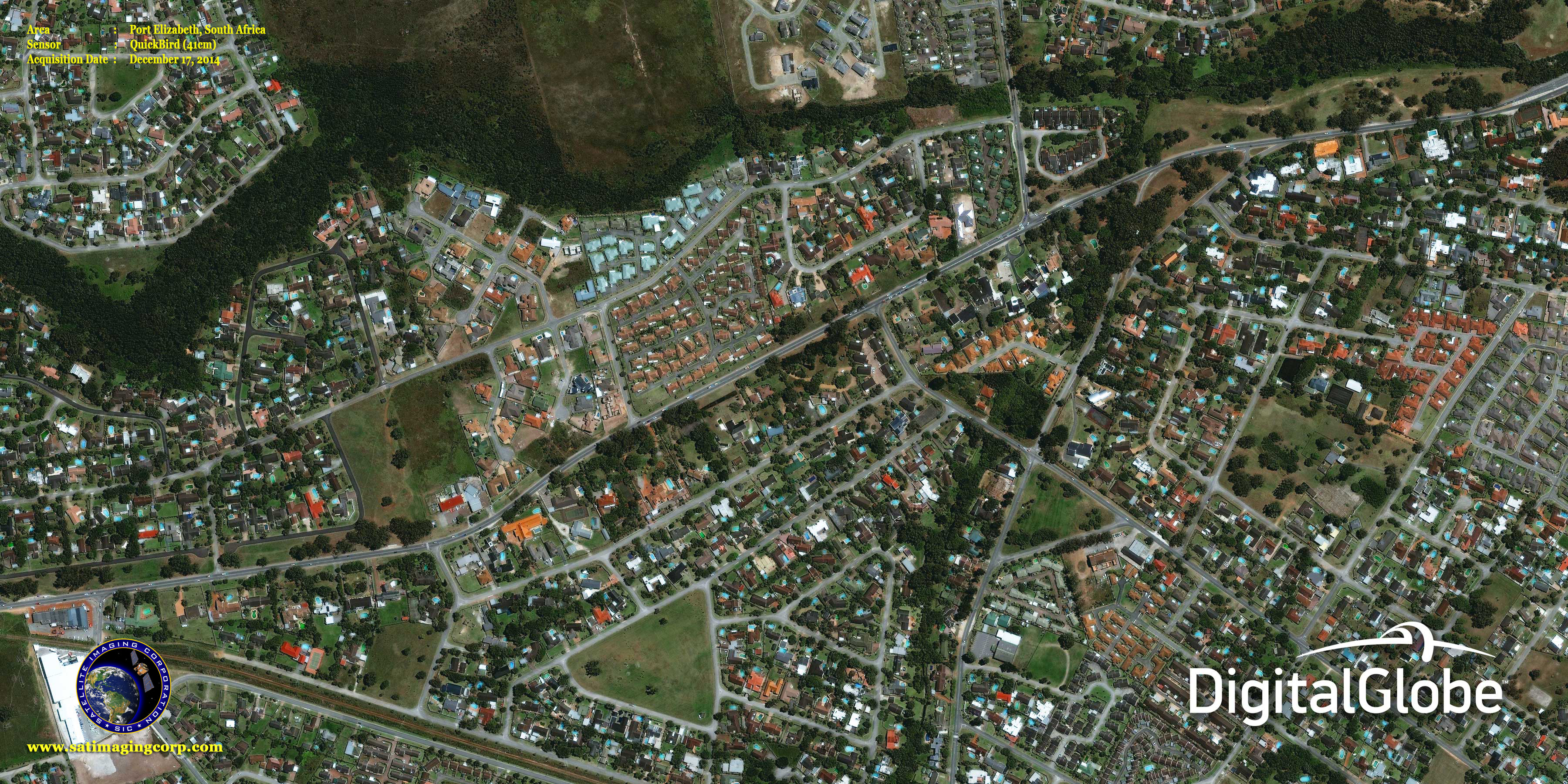
    In its final orbit before its imager was turned off, QuickBird captured a stunning view of Port Elizabeth, South Africa, on December 17, 2014, available in the gallery page. The satellite’s orbit had decayed to approximately 300 kilometers, resulting in an image with incredible ground resolution of 41 cm.

    Ball Aerospace & Technologies Corp. developed QuickBird, which was the highest resolution commercial satellite at the time, as well as DigitalGlobe’s subsequent WorldView-1, WorldView-2, and WorldView-3 satellites. QuickBird played a key role in the establishment of the commercial remote sensing industry and helped pave the way for what is now the world’s most capable imaging satellite constellation.

    QuickBird imagery dating back to 2002 will remain available in the QuickBird imagery archives available here.

    QuickBird Satellite Sensor Characteristics

    Launch DateOctober 18, 2001
    Launch VehicleBoeing Delta II
    Launch LocationVandenberg Air Force Base, California, USA
    Orbit Altitude450 Km / 482 Km - (Early 2013)
    Orbit Inclination97.2°, sun-synchronous
    Speed7.1 Km/sec (25,560 Km/hour)
    Equator Crossing Time10:30 AM (descending node)
    Orbit Time93.5 minutes
    Revisit Time1-3.5 days, depending on latitude (30° off-nadir)
    Swath Width (Nadir)16.8 Km / 18 Km - (Early 2013)
    Metric Accuracy23 meter horizontal (CE90)
    Digitization11 bits
    Resolution

    Pan: 65 cm (nadir) to 73 cm (20° off-nadir)

    MS: 2.62 m (nadir) to 2.90 m (20° off-nadir)

    Image Bands

    Pan: 450-900 nm

    Blue: 450-520 nm

    Green: 520-600 nm

    Red: 630-690 nm

    Near IR: 760-900 nm

    QuickBird Specifications - PDF Download

    Archived QuickBird Imagery

    For many image requests, a matching image can already be located in the archives of high-resolution QuickBird imagery from around the world. If no image data is available in the archives, new high resolution satellite image data can be acquired through a satellite tasking process. For more information and pricing, please contact us.

    Satellites Currently Operated by DigitalGlobe

    WorldView-4 Satellite Sensor (0.31m)

    WorldView-3 Satellite Sensor (0.31m)

    GeoEye-1 Satellite Sensor (0.5m)

    For more information on our products and services or for a consultation, please contact us.

    Satellite Imaging Corporation is an official Value Added Reseller (VAR) of imaging and geospatial data products for:
    An AIRBUS Value Added ResellerA Twenty First Century Aerospace Technology Value Added Reseller

    Technical documents are available for this sensor. Choose one to download it.

    • QuickBird Product Guide
    We offer satellite imagery and data from the most technologically advanced satellite sensors. Please choose one to learn more.
    • WorldView-4 (0.31m)
    • WorldView-3 (0.31m)
    • WorldView-2 (0.46m)
    • WorldView-1 (0.46m)
    • GeoEye-1 (0.46m)
    • Pleiades-1A (0.5m)
    • Pleiades-1B (0.5m)
    • SuperView-1 (0.5m)
    • KOMPSAT-3A (0.55m)
    • KOMPSAT-3 (0.7m)
    • QuickBird (0.65m)
    • Gaofen-2 (0.8m)
    • TripleSat (0.8m)
    • IKONOS (0.82m)
      • IKONOS Stereo Imagery
    • SkySat-1 (0.8m)
    • SkySat-2 (0.8m)
    • Jilin-1 (1m)
    • TerraSAR-X
    • SPOT-6 (1.5m)
    • SPOT-7 (1.5m)
    • Other Satellites (2m-20m)
    GeoEye-1 WorldView-1 WorldView-2 Pleiades-1A QuickBird IKONOS SPOT-6 SPOT-5 RapidEye ASTER LANDSAT-7
    • Satellites
    • Applications
    • Gallery
    • Services
    • About
      • Terms of Use
      • Privacy Policy
      • Site Map

    Copyright © 2001-2017 Satellite Imaging Corporation. All rights reserved.

    Facebook Twitter LinkedIn