• Satellites
    • WorldView-4 (0.31m)
    • WorldView-3 (0.31m)
    • WorldView-2 (0.46m)
    • WorldView-1 (0.46m)
    • GeoEye-1 (0.46m)
    • Pleiades-1A (0.5m)
    • Pleiades-1B (0.5m)
    • SuperView-1 (0.5m)
    • KOMPSAT-3A (0.55m)
    • KOMPSAT-3 (0.7m)
    • QuickBird (0.65m)
    • Gaofen-2 (0.8m)
    • TripleSat (0.8m)
    • IKONOS (0.82m)
      • IKONOS Stereo Imagery
    • SkySat-1 (0.8m)
    • SkySat-2 (0.8m)
    • Jilin-1 (1m)
      • Jilin-1 Optical Satellite
      • Jilin-1 Smart Video Satellite
      • Jilin-1 Hyperspectral Satellite
    • TerraSAR-X
    • SPOT-6 (1.5m)
    • SPOT-7 (1.5m)
    • Other Satellites (2m-20m)
      • FORMOSAT-2 (2m)
      • TH-01 (2m)
      • ALOS (2.5m)
      • CARTOSAT-1 (2.5m)
      • SPOT-5 (2.5m-5m)
      • Dove (3m)
      • RapidEye (5m)
      • Sentinel-2A (10m)
      • LANDSAT 7 ETM+ (15m)
      • LANDSAT 8 (15m)
      • ASTER (15m)
      • CBERS-2 (20m)
  • Applications
    • Energy
      • Mining
      • Oil and Gas
        • Oil and Gas Development
        • Oil and Gas Exploration
        • Oil and Gas Production
      • Pipeline and Transmission
    • Engineering and Construction
      • 3D Urban and Terrain Modeling
      • Airport Mapping Database
      • Cadastre and Land Records
      • Urban and Land Development
    • Defense and Security
      • Crime Mapping
      • Homeland Security
    • Environmental Management
      • Global Climate Change
      • Urban Planning
      • Conservation
        • Archaeology
        • Coastal Management
        • Habitat Mapping
        • Wildlife Monitoring
      • Land Cover and Change Detection
      • Natural Disasters
        • Hurricanes
      • Natural Hazards
        • Landslides
    • Media and Entertainment
    • Natural Resources
      • Agriculture Mapping
        • Vegetation Index Maps
        • GVI Sample Images
        • Soil Zone Index
        • TreeGrading Maps
      • Forestry
      • Soil Moisture and Ocean Salinity
    • Tourism
  • Gallery
    • WorldView-4
    • WorldView-3
    • WorldView-2
    • WorldView-1
    • GeoEye-1
    • Pleiades-1A
    • Pleiades-1B
    • KOMPSAT-3
    • QuickBird
    • IKONOS
    • SkySat-1
    • SkySat-2
    • TripleSat
    • TerraSAR-X
    • SPOT-6
    • SPOT-7
    • TH-01
    • RapidEye
    • LANDSAT 7 ETM+
    • LANDSAT 8
    • High Resolution
    • Medium Resolution
    • 3D Terrain Flythroughs
    • 3D Terrain Modelling
    • Geographic Information Systems (GIS)
    • Historical Sites
    • More Imagery
      • ALOS
      • CARTOSAT-1
      • SPOT-5
      • Dove
      • Sentinel-2A
      • ASTER
      • CBERS-2
      • FORMOSAT-2
      • Aerial Photos
  • Services
    • 3D Terrain Modelling
    • ATCOR
    • Atmospheric Compensation
    • Consultancy
    • 3D Digital Surface
    • Feature Extraction
    • Geographic Information Systems
    • Image Processing
    • Orthorectification
    • Resources
      • Geospatial Technology
      • Remote Sensing
  • About
    • Press
    • Blog
  • Blog
  • Press
  • Contact Us
Blog Press Contact Us
Satellite Imaging Corporation
  • Satellite Imaging Corporation
  • Satellites
    • WorldView-4 (0.31m)
    • WorldView-3 (0.31m)
    • WorldView-2 (0.46m)
    • WorldView-1 (0.46m)
    • GeoEye-1 (0.46m)
    • Pleiades-1A (0.5m)
    • Pleiades-1B (0.5m)
    • SuperView-1 (0.5m)
    • KOMPSAT-3A (0.55m)
    • KOMPSAT-3 (0.7m)
    • QuickBird (0.65m)
    • Gaofen-2 (0.8m)
    • TripleSat (0.8m)
    • IKONOS (0.82m)
      • IKONOS Stereo Imagery
    • SkySat-1 (0.8m)
    • SkySat-2 (0.8m)
    • Jilin-1 (1m)
      • Jilin-1 Optical Satellite
      • Jilin-1 Smart Video Satellite
      • Jilin-1 Hyperspectral Satellite
    • TerraSAR-X
    • SPOT-6 (1.5m)
    • SPOT-7 (1.5m)
    • Other Satellites (2m-20m)
      • FORMOSAT-2 (2m)
      • TH-01 (2m)
      • ALOS (2.5m)
      • CARTOSAT-1 (2.5m)
      • SPOT-5 (2.5m-5m)
      • Dove (3m)
      • RapidEye (5m)
      • Sentinel-2A (10m)
      • LANDSAT 7 ETM+ (15m)
      • LANDSAT 8 (15m)
      • ASTER (15m)
      • CBERS-2 (20m)
  • Applications
    • Energy
      • Mining
      • Oil and Gas
        • Oil and Gas Development
        • Oil and Gas Exploration
        • Oil and Gas Production
      • Pipeline and Transmission
    • Engineering and Construction
      • 3D Urban and Terrain Modeling
      • Airport Mapping Database
      • Cadastre and Land Records
      • Urban and Land Development
    • Defense and Security
      • Crime Mapping
      • Homeland Security
    • Environmental Management
      • Global Climate Change
      • Urban Planning
      • Conservation
        • Archaeology
        • Coastal Management
        • Habitat Mapping
        • Wildlife Monitoring
      • Land Cover and Change Detection
      • Natural Disasters
        • Hurricanes
      • Natural Hazards
        • Landslides
    • Media and Entertainment
    • Natural Resources
      • Agriculture Mapping
        • Vegetation Index Maps
        • GVI Sample Images
        • Soil Zone Index
        • TreeGrading Maps
      • Forestry
      • Soil Moisture and Ocean Salinity
    • Tourism
  • Gallery
    • WorldView-4
    • WorldView-3
    • WorldView-2
    • WorldView-1
    • GeoEye-1
    • Pleiades-1A
    • Pleiades-1B
    • KOMPSAT-3
    • QuickBird
    • IKONOS
    • SkySat-1
    • SkySat-2
    • TripleSat
    • TerraSAR-X
    • SPOT-6
    • SPOT-7
    • TH-01
    • RapidEye
    • LANDSAT 7 ETM+
    • LANDSAT 8
    • High Resolution
    • Medium Resolution
    • 3D Terrain Flythroughs
    • 3D Terrain Modelling
    • Geographic Information Systems (GIS)
    • Historical Sites
    • More Imagery
      • ALOS
      • CARTOSAT-1
      • SPOT-5
      • Dove
      • Sentinel-2A
      • ASTER
      • CBERS-2
      • FORMOSAT-2
      • Aerial Photos
  • Services
    • 3D Terrain Modelling
    • ATCOR
    • Atmospheric Compensation
    • Consultancy
    • 3D Digital Surface
    • Feature Extraction
    • Geographic Information Systems
    • Image Processing
    • Orthorectification
    • Resources
      • Geospatial Technology
      • Remote Sensing
  • About
    • Press
    • Blog
  • Search

    Pleiades-1A Satellite Sensor

    Discover what's possible. Get a complimentary consultation today.
    Contact Us Now
    • Home
    • Satellites
    • Pleiades-1A (0.5m)

    Pleiades-1A Satellite Sensor (0.5m)

    AIRBUS Defence & Space Pleiades-1A satellite sensor was successfully launched on December 16, 2011 and provides 0.5m high resolution satellite image data. Watch video of Pleiades-1A satellite launch.

    Pleiades-1A Satellite Sensor (0.5m)

    Pleiades-1A Satellite Sensor (0.5m)

    (Image Copyright © AIRBUS Defence & Space)

    The Pleiades-1A satellite is capable of providing orthorectified color data at 0.5-meter resolution (roughly comparable to GeoEye-1) and revisiting any point on Earth as it covers a total of 1 million square kilometers (approximately 386,102 square miles) daily. Perhaps most importantly, Pleiades-1A is capable of acquiring high-resolution stereo imagery in just one pass, and can accommodate large areas (up to 1,000 km x 1,000 km).

    The Pleiades-1A satellite features four spectral bands (blue, green, red, and IR), as well as image location accuracy of 3 meters (CE90) without ground control points. Image location accuracy can be improved even further — up to an exceptional 1 meter — by the use of GCPs. Because the satellite has been designed with urgent tasking in mind, images can be requested from Pleiades-1A less than six hours before they are acquired. This functionality will prove invaluable in situations where the expedited collection of new image data is crucial, such as crisis monitoring.

    Sample Images

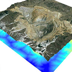
    Bingham Copper Mine - 3D ArcScene

    Bingham Copper Mine

    3D ArcScene

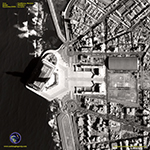
    Casablanca, Morrocco

    Casablanca, Morrocco

    Mosque

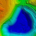
    Bingham Copper Mine - 1M DEM

    Bingham Copper Mine

    1M DEM

    Pleiades-1A Satellite Image Gallery

    Pleiades-1A Satellite Sensor Characteristics

    Imagery Products50-cm panchromatic
    50-cm color (pansharpened)
    2-meter multispectral
    Bundle: 50-cm panchromatic and 2-meter multispectral
    Spectral BandsP: 480-830 nm
    Blue: 430-550 nm
    Green: 490-610 nm
    Red: 600-720 nm
    Near Infrared: 750-950 nm
    Preprocessing LevelsSensor
    Ortho
    Image Location AccuracyWith ground control points: 1m
    Without ground control points: 3m (CE90)
    Imaging CapacityDaily constellation capacity: 1,000,000 sq.km.
    Strip mapping (mosaic): 100 km x 100 km
    Stereo imaging: 20 km x 280 km
    Max. spots over 100 km x 200 km: 30 (crisis mode)
    Imaging Swath20 km at nadir
    Revisit IntervalDaily (Pleiades-1A and 1B)

    Pleiades Specifications - PDF Download

    Satellites Currently Operated by AIRBUS Defence & Space

    Pleiades-1B Satellite Sensor (0.5m)

    SPOT-7 Satellite Sensor (1.5m)

    SPOT-6 Satellite Sensor (1.5m)

    FORMOSAT-2 Satellite Sensor (2m)

    SPOT-5 Satellite Sensor (2.5/5m)

    Satellite Imaging Corporation is an official Value Added Reseller (VAR) of imaging and geospatial data products for:
    An AIRBUS Value Added ResellerA Twenty First Century Aerospace Technology Value Added Reseller

    Additional information is available for this satellite. Choose a document to download it.

    • Pleiades User Guide
    We offer satellite imagery and data from the most technologically advanced satellite sensors. Please choose one to learn more.
    • WorldView-4 (0.31m)
    • WorldView-3 (0.31m)
    • WorldView-2 (0.46m)
    • WorldView-1 (0.46m)
    • GeoEye-1 (0.46m)
    • Pleiades-1A (0.5m)
    • Pleiades-1B (0.5m)
    • SuperView-1 (0.5m)
    • KOMPSAT-3A (0.55m)
    • KOMPSAT-3 (0.7m)
    • QuickBird (0.65m)
    • Gaofen-2 (0.8m)
    • TripleSat (0.8m)
    • IKONOS (0.82m)
      • IKONOS Stereo Imagery
    • SkySat-1 (0.8m)
    • SkySat-2 (0.8m)
    • Jilin-1 (1m)
    • TerraSAR-X
    • SPOT-6 (1.5m)
    • SPOT-7 (1.5m)
    • Other Satellites (2m-20m)
    GeoEye-1 WorldView-1 WorldView-2 Pleiades-1A QuickBird IKONOS SPOT-6 SPOT-5 RapidEye ASTER LANDSAT-7
    • Satellites
    • Applications
    • Gallery
    • Services
    • About
      • Terms of Use
      • Privacy Policy
      • Site Map

    Copyright © 2001-2017 Satellite Imaging Corporation. All rights reserved.

    Facebook Twitter LinkedIn