• Satellites
    • WorldView-4 (0.31m)
    • WorldView-3 (0.31m)
    • WorldView-2 (0.46m)
    • WorldView-1 (0.46m)
    • GeoEye-1 (0.46m)
    • Pleiades-1A (0.5m)
    • Pleiades-1B (0.5m)
    • SuperView-1 (0.5m)
    • KOMPSAT-3A (0.55m)
    • KOMPSAT-3 (0.7m)
    • QuickBird (0.65m)
    • Gaofen-2 (0.8m)
    • TripleSat (0.8m)
    • IKONOS (0.82m)
      • IKONOS Stereo Imagery
    • SkySat-1 (0.8m)
    • SkySat-2 (0.8m)
    • Jilin-1 (1m)
      • Jilin-1 Optical Satellite
      • Jilin-1 Smart Video Satellite
      • Jilin-1 Hyperspectral Satellite
    • TerraSAR-X
    • SPOT-6 (1.5m)
    • SPOT-7 (1.5m)
    • Other Satellites (2m-20m)
      • FORMOSAT-2 (2m)
      • TH-01 (2m)
      • ALOS (2.5m)
      • CARTOSAT-1 (2.5m)
      • SPOT-5 (2.5m-5m)
      • Dove (3m)
      • RapidEye (5m)
      • Sentinel-2A (10m)
      • LANDSAT 7 ETM+ (15m)
      • LANDSAT 8 (15m)
      • ASTER (15m)
      • CBERS-2 (20m)
  • Applications
    • Energy
      • Mining
      • Oil and Gas
        • Oil and Gas Development
        • Oil and Gas Exploration
        • Oil and Gas Production
      • Pipeline and Transmission
    • Engineering and Construction
      • 3D Urban and Terrain Modeling
      • Airport Mapping Database
      • Cadastre and Land Records
      • Urban and Land Development
    • Defense and Security
      • Crime Mapping
      • Homeland Security
    • Environmental Management
      • Global Climate Change
      • Urban Planning
      • Conservation
        • Archaeology
        • Coastal Management
        • Habitat Mapping
        • Wildlife Monitoring
      • Land Cover and Change Detection
      • Natural Disasters
        • Hurricanes
      • Natural Hazards
        • Landslides
    • Media and Entertainment
    • Natural Resources
      • Agriculture Mapping
        • Vegetation Index Maps
        • GVI Sample Images
        • Soil Zone Index
        • TreeGrading Maps
      • Forestry
      • Soil Moisture and Ocean Salinity
    • Tourism
  • Gallery
    • WorldView-4
    • WorldView-3
    • WorldView-2
    • WorldView-1
    • GeoEye-1
    • Pleiades-1A
    • Pleiades-1B
    • KOMPSAT-3
    • QuickBird
    • IKONOS
    • SkySat-1
    • SkySat-2
    • TripleSat
    • TerraSAR-X
    • SPOT-6
    • SPOT-7
    • TH-01
    • RapidEye
    • LANDSAT 7 ETM+
    • LANDSAT 8
    • High Resolution
    • Medium Resolution
    • 3D Terrain Flythroughs
    • 3D Terrain Modelling
    • Geographic Information Systems (GIS)
    • Historical Sites
    • More Imagery
      • ALOS
      • CARTOSAT-1
      • SPOT-5
      • Dove
      • Sentinel-2A
      • ASTER
      • CBERS-2
      • FORMOSAT-2
      • Aerial Photos
  • Services
    • 3D Terrain Modelling
    • ATCOR
    • Atmospheric Compensation
    • Consultancy
    • 3D Digital Surface
    • Feature Extraction
    • Geographic Information Systems
    • Image Processing
    • Orthorectification
    • Resources
      • Geospatial Technology
      • Remote Sensing
  • About
    • Press
    • Blog
  • Blog
  • Press
  • Contact Us
Blog Press Contact Us
Satellite Imaging Corporation
  • Satellite Imaging Corporation
  • Satellites
    • WorldView-4 (0.31m)
    • WorldView-3 (0.31m)
    • WorldView-2 (0.46m)
    • WorldView-1 (0.46m)
    • GeoEye-1 (0.46m)
    • Pleiades-1A (0.5m)
    • Pleiades-1B (0.5m)
    • SuperView-1 (0.5m)
    • KOMPSAT-3A (0.55m)
    • KOMPSAT-3 (0.7m)
    • QuickBird (0.65m)
    • Gaofen-2 (0.8m)
    • TripleSat (0.8m)
    • IKONOS (0.82m)
      • IKONOS Stereo Imagery
    • SkySat-1 (0.8m)
    • SkySat-2 (0.8m)
    • Jilin-1 (1m)
      • Jilin-1 Optical Satellite
      • Jilin-1 Smart Video Satellite
      • Jilin-1 Hyperspectral Satellite
    • TerraSAR-X
    • SPOT-6 (1.5m)
    • SPOT-7 (1.5m)
    • Other Satellites (2m-20m)
      • FORMOSAT-2 (2m)
      • TH-01 (2m)
      • ALOS (2.5m)
      • CARTOSAT-1 (2.5m)
      • SPOT-5 (2.5m-5m)
      • Dove (3m)
      • RapidEye (5m)
      • Sentinel-2A (10m)
      • LANDSAT 7 ETM+ (15m)
      • LANDSAT 8 (15m)
      • ASTER (15m)
      • CBERS-2 (20m)
  • Applications
    • Energy
      • Mining
      • Oil and Gas
        • Oil and Gas Development
        • Oil and Gas Exploration
        • Oil and Gas Production
      • Pipeline and Transmission
    • Engineering and Construction
      • 3D Urban and Terrain Modeling
      • Airport Mapping Database
      • Cadastre and Land Records
      • Urban and Land Development
    • Defense and Security
      • Crime Mapping
      • Homeland Security
    • Environmental Management
      • Global Climate Change
      • Urban Planning
      • Conservation
        • Archaeology
        • Coastal Management
        • Habitat Mapping
        • Wildlife Monitoring
      • Land Cover and Change Detection
      • Natural Disasters
        • Hurricanes
      • Natural Hazards
        • Landslides
    • Media and Entertainment
    • Natural Resources
      • Agriculture Mapping
        • Vegetation Index Maps
        • GVI Sample Images
        • Soil Zone Index
        • TreeGrading Maps
      • Forestry
      • Soil Moisture and Ocean Salinity
    • Tourism
  • Gallery
    • WorldView-4
    • WorldView-3
    • WorldView-2
    • WorldView-1
    • GeoEye-1
    • Pleiades-1A
    • Pleiades-1B
    • KOMPSAT-3
    • QuickBird
    • IKONOS
    • SkySat-1
    • SkySat-2
    • TripleSat
    • TerraSAR-X
    • SPOT-6
    • SPOT-7
    • TH-01
    • RapidEye
    • LANDSAT 7 ETM+
    • LANDSAT 8
    • High Resolution
    • Medium Resolution
    • 3D Terrain Flythroughs
    • 3D Terrain Modelling
    • Geographic Information Systems (GIS)
    • Historical Sites
    • More Imagery
      • ALOS
      • CARTOSAT-1
      • SPOT-5
      • Dove
      • Sentinel-2A
      • ASTER
      • CBERS-2
      • FORMOSAT-2
      • Aerial Photos
  • Services
    • 3D Terrain Modelling
    • ATCOR
    • Atmospheric Compensation
    • Consultancy
    • 3D Digital Surface
    • Feature Extraction
    • Geographic Information Systems
    • Image Processing
    • Orthorectification
    • Resources
      • Geospatial Technology
      • Remote Sensing
  • About
    • Press
    • Blog
  • Search

    IKONOS Satellite Sensor

    Discover what's possible. Get a complimentary consultation today.
    Contact Us Now
    • Home
    • Satellites
    • IKONOS (0.82m)

    IKONOS Satellite Sensor (0.82m) - Decommissioned

    The IKONOS satellite sensor was successfully launched as the first commercially available high resolution satellite sensor on September 24, 1999 at Vandenberg Air Force Base, California, USA.

    IKONOS Satellite Sensor (0.82m)

    IKONOS Satellite Sensor

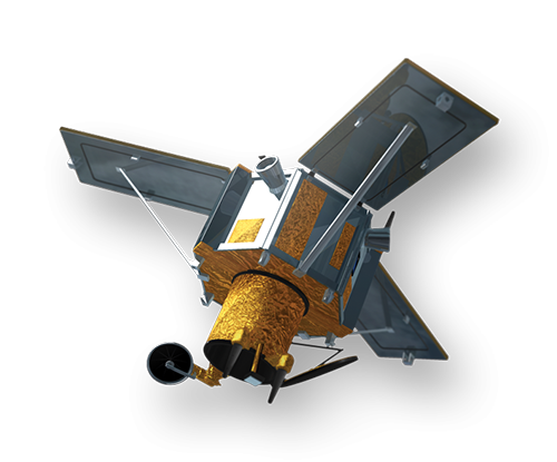
    (Image Copyright © DigitalGlobe)

    The IKONOS satellite sensor is a high-resolution satellite operated by DigitalGlobe. Its capabilities include capturing a 3.2m multispectral, Near-Infrared (NIR) 0.82m panchromatic resolution at nadir. Its applications include both urban and rural mapping of natural resources and of natural disasters, tax mapping, agriculture and forestry analysis, mining, engineering, construction, and change detection. It can yield relevant data for nearly all aspects of environmental study. IKONOS images have also been procured by Satellite Imaging Corporation for use in the media and motion picture industries, providing aerial views and satellite photos for many areas around the world. Its high resolution data makes an integral contribution to homeland security, coastal monitoring and facilitates 3D Digital Terrain Models (DTMs) and Digital Elevation Models (DEMs).

    IKONOS Satellite Sensor Status Update

    On January 22, 2015 DigitalGlobe announced that during recent maintenance activities, DigitalGlobe attempted to resolve an irregularity in the accuracy of imagery collected by the IKONOS satellite sensor. After extensive testing, DigitalGlobe haas determined that the accuracy of IKONOS imagery does not meet DigitalGlobe’s product quality specifications, and subsequently, the established A3C (Accuracy, Currency, Completeness, and Consistency) quality standards. DigitalGlobe will not accept new IKONOS tasking orders.

    More information on Stereo IKONOS Satellite.

    Sample Images

    Fukushima Nuclear Plant - Post Tsunami and Earthquake

    Fukushima Nuclear Plant

    Post Tsunami

    Cambodia - Ankor Wat

    Ankor Wat

    Cambodia

    Rumalia, Iraq - Oil Facility

    Rumalia, Iraq

    Oil Facility

    Atmospheric Compensation - DigitalGlobe AComp Pre-Processing

    IKONOS Archived Satellite Image Gallery

    IKONOS Satellite Sensor Characteristics

    Launch Date24 September 1999 at Vandenberg Air Force Base, California, USA
    Operational LifeOver 7 years
    Orbit98.1 degree, sun synchronous
    Speed on Orbit7.5 kilometers per second
    Speed Over the Ground6.8 kilometers per second
    Revolutions Around the Earth14.7, every 24 hours
    Altitude681 kilometers
    Resolution at Nadir0.82 meters panchromatic; 3.28 meters multispectral
    Resolution 26° Off-Nadir1.0 meter panchromatic; 4.0 meters multispectral
    Image Swath11.3 kilometers at nadir; 13.8 kilometers at 26° off-nadir
    Equator Crossing TimeNominally 10:30 AM solar time
    Revisit TimeApproximately 3 days at 40° latitude
    Dynamic Range11-bits per pixel
    Image BandsPanchromatic, blue, green, red, near IR

    IKONOS Specifications - PDF Download

    Satellites Currently Operated by DigitalGlobe

    WorldView-4 Satellite Sensor (0.31m)

    WorldView-3 Satellite Sensor (0.31m)

    WorldView-2 Satellite Sensor (0.46m)

    WorldView-1 Satellite Sensor (0.46m)

    GeoEye-1 Satellite Sensor (0.5m)

    QuickBird Satellite Sensor (0.65m)

    For more information on our products and services or for a consultation, please contact us.

    Satellite Imaging Corporation is an official Value Added Reseller (VAR) of imaging and geospatial data products for:
    An AIRBUS Value Added ResellerA Twenty First Century Aerospace Technology Value Added Reseller

    Technical documents are available for this sensor. Choose one to download it.

    • IKONOS Geometric Accuracy
    We offer satellite imagery and data from the most technologically advanced satellite sensors. Please choose one to learn more.
    • WorldView-4 (0.31m)
    • WorldView-3 (0.31m)
    • WorldView-2 (0.46m)
    • WorldView-1 (0.46m)
    • GeoEye-1 (0.46m)
    • Pleiades-1A (0.5m)
    • Pleiades-1B (0.5m)
    • SuperView-1 (0.5m)
    • KOMPSAT-3A (0.55m)
    • KOMPSAT-3 (0.7m)
    • QuickBird (0.65m)
    • Gaofen-2 (0.8m)
    • TripleSat (0.8m)
    • IKONOS (0.82m)
      • IKONOS Stereo Imagery
    • SkySat-1 (0.8m)
    • SkySat-2 (0.8m)
    • Jilin-1 (1m)
    • TerraSAR-X
    • SPOT-6 (1.5m)
    • SPOT-7 (1.5m)
    • Other Satellites (2m-20m)
    GeoEye-1 WorldView-1 WorldView-2 Pleiades-1A QuickBird IKONOS SPOT-6 SPOT-5 RapidEye ASTER LANDSAT-7
    • Satellites
    • Applications
    • Gallery
    • Services
    • About
      • Terms of Use
      • Privacy Policy
      • Site Map

    Copyright © 2001-2017 Satellite Imaging Corporation. All rights reserved.

    Facebook Twitter LinkedIn