- USGS Report Updates Economic Value of Landsat Archive
Mon, 11 Nov 2019 - Landsat Images Help Wyoming Students Discern Problems on Family Lands
Tue, 29 Oct 2019 - Lakes Worldwide Are Experiencing More-Severe Algal Blooms, 30-years of Landsat Data Shows
Mon, 14 Oct 2019 - Pecora Award Honors Excellence in Earth Observation, Including Former Landsat Science Team Leader
Tue, 08 Oct 2019 - Landsat 9 Instrument Ready for Spacecraft Assembly
Fri, 27 Sep 2019 - Geoscience is Everywhere: 2019 Earth Science Week Poster
Mon, 16 Sep 2019
Landsat 8

Data

Recent Imagery
How Landsat Helps


The Landsat Program
This joint NASA/USGS program provides the longest continuous space-based record of Earth’s land in existence. Every day, Landsat satellites provide essential information to help land managers and policy makers make wise decisions about our resources and our environment. + Landsat Case Studies ebook
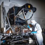
Landsat 9 Instrument Ready for Spacecraft Assembly
OLI-2 is now built, tested, and in place to be assembled onto the spacecraft.
+ details
+ details

New Landsat Infrared Instrument Ships from NASA
This month, TIRS-2 successfully passed the stringent 12-week testing process at NASA’s Goddard Space Flight Center and was shipped to Northrop […]

More than Naught: The “Z” of Where Land Meets Sea
Harnessing 30 years of Landsat data, a team of researchers from Australia has created the first 3D model of Australia’s entire coastline.[…]
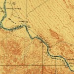
Geographia
Journey with us into the cartographic past. Latest look: Creating an Oasis in the Desert: Lake Havasu City, Arizona, 1911 […]