| Frida: Free Vector Geodata Osnabrück | ||
|
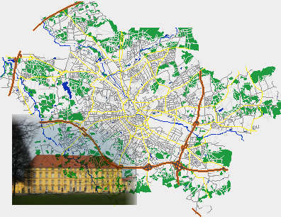
This project developed a free dataset of geographic vector information for the German city Osnabrück (State Lower Saxony). The data is free in the sence of Free Software and licensed under the GNU General Public License (GNU GPL v>=2). Since 2007 it is additionally available under the Creative Commons Attribution-ShareAlike 2.0 license and the Open Database License (ODbL) from OpenStreetMap. Frida was a great success, the geographical data has been used by many projects e.g. Thuban, GRASS and others to demonstrate the capabilities of Free Software for handling geographic data and teach GIS. Detailed free geographic vector data almost unavailable for Europe at all in 2002. Only the USA released significant data paid by taxes to the public. We hope that Europeans will also release more data to the public under liberal terms, since it would benefit the use of geographic information in our society for private and commercial purposes. Successful efforts like Frida will help to convince the European governments to change their mind. So OpenStreetMap is very welcome and Frida's data was transfered to them. Please join OpenStreetMap to further improve the data situation for Osnabrück and other parts of the world. |
||
| ->deutsch | ||||||||
| Info | ||||||||
|
||||||||
| Interaktive Karte | ||||||||
|
||||||||
| Verweise | ||||||||
|
||||||||